Archived News Items
November 1, 2018 - SGCI congratulates the GABBs team on its new NSF grant to develop GeoEDF!
December 10, 2018 - Rajesh demonstrating MyGeoHub at ESIP Data Help Desk, AGU Fall Meeting, Washington D.C.
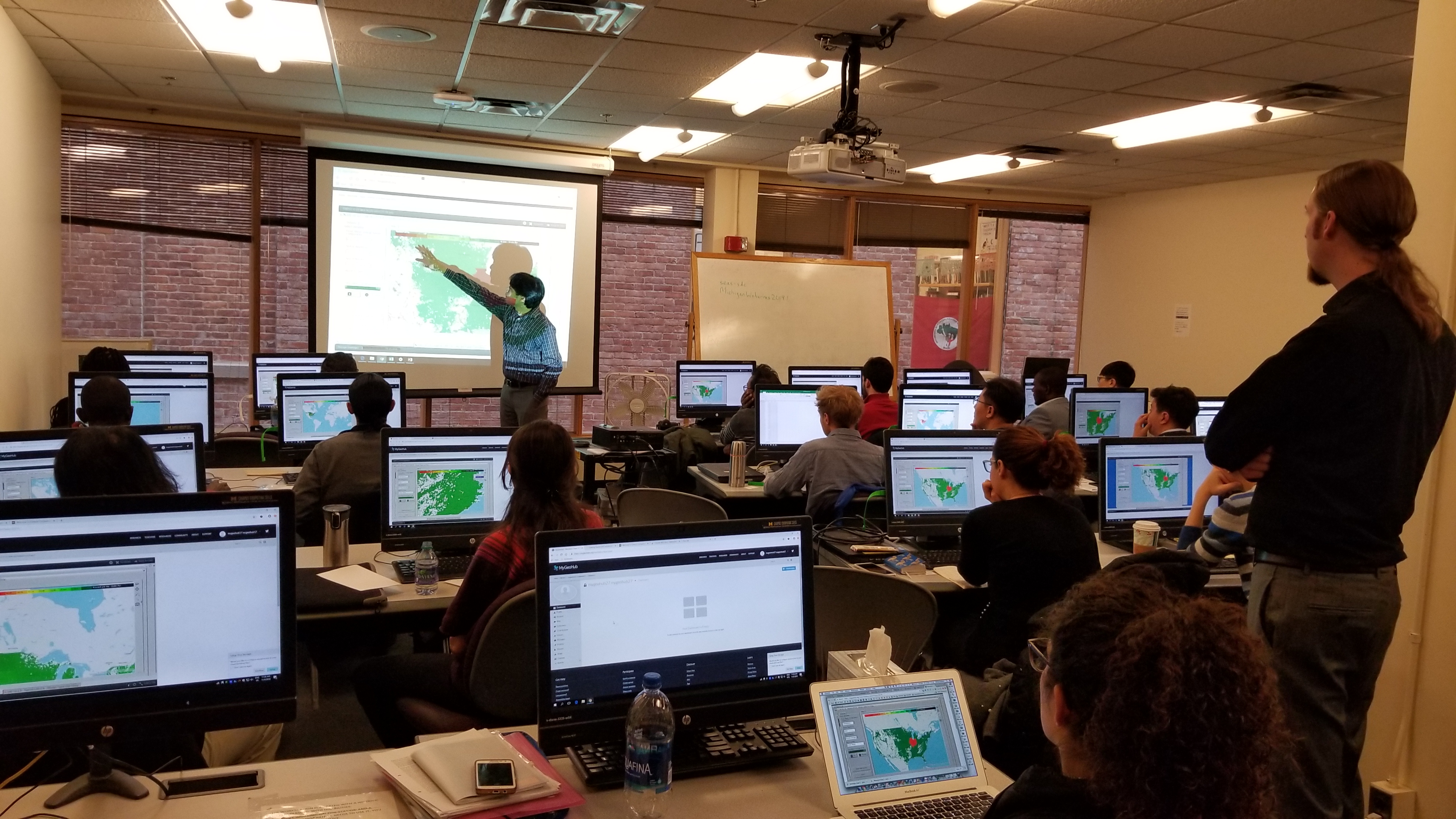
November 9, 2018 - MyGeoHub and SIMPLE-G in action at the workshop of Open-Source Analysis of SDGs at the Food-Water-Energy Nexus Using Global Gridded Modeling, Ann Arbor
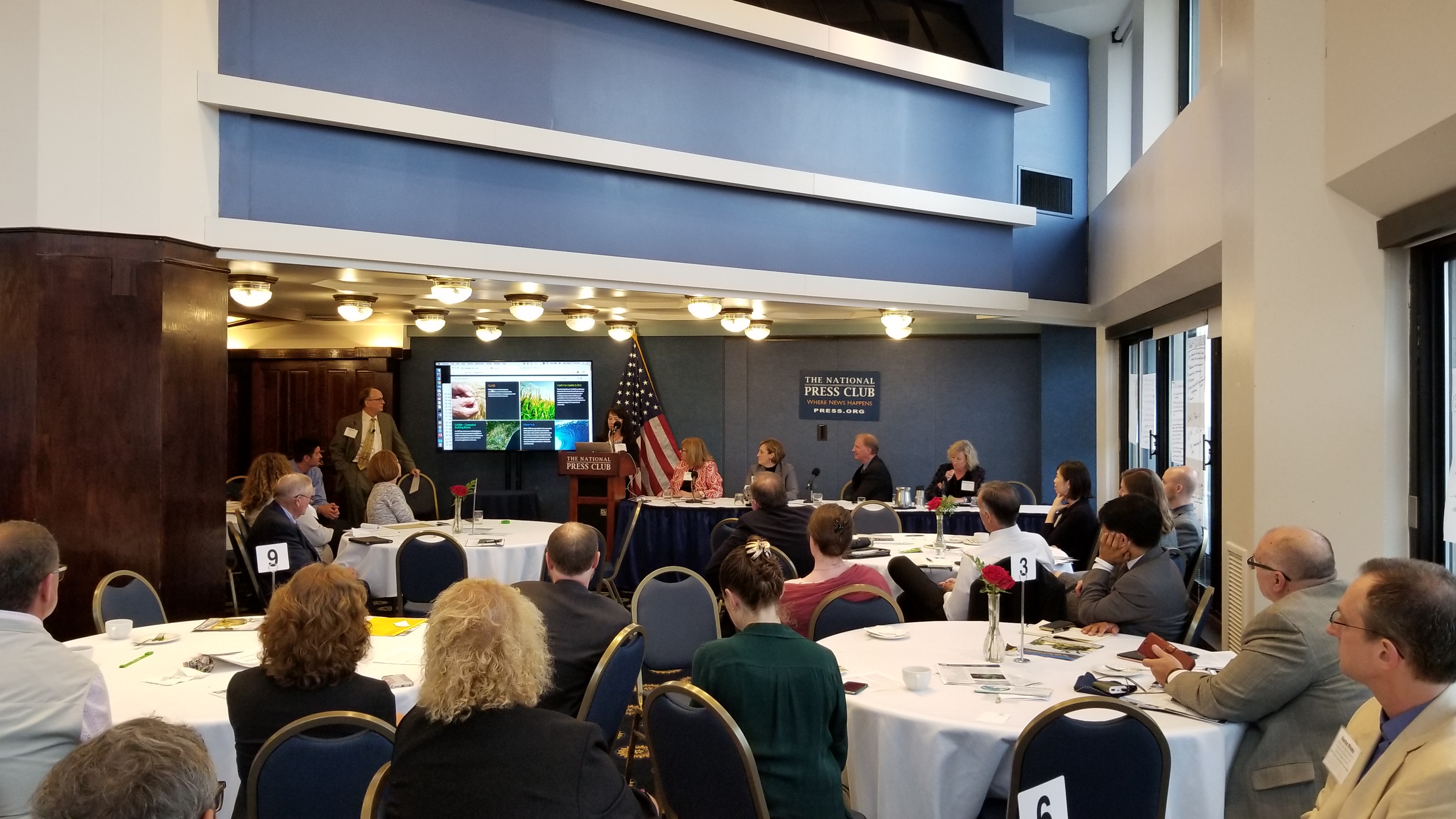
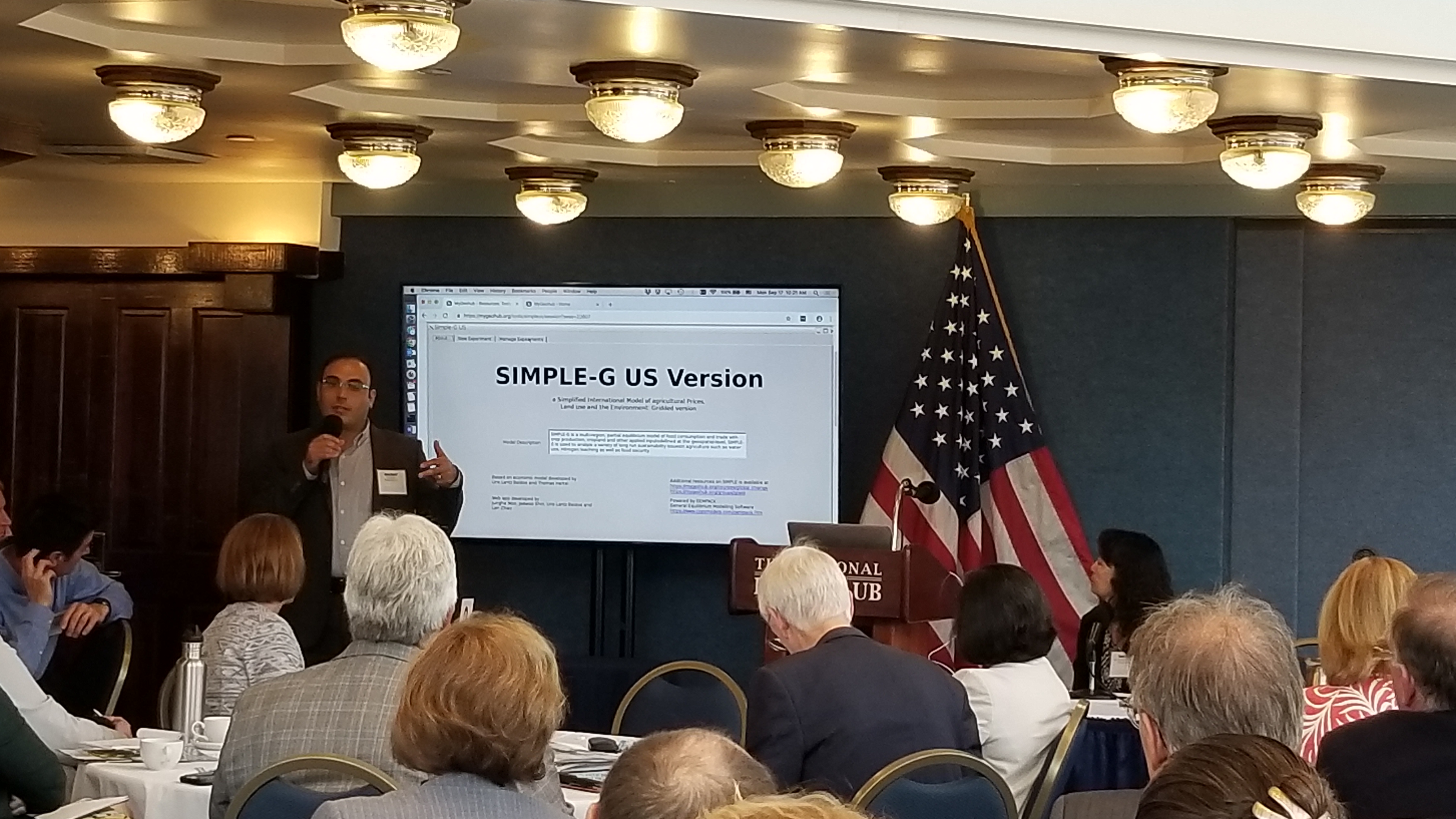
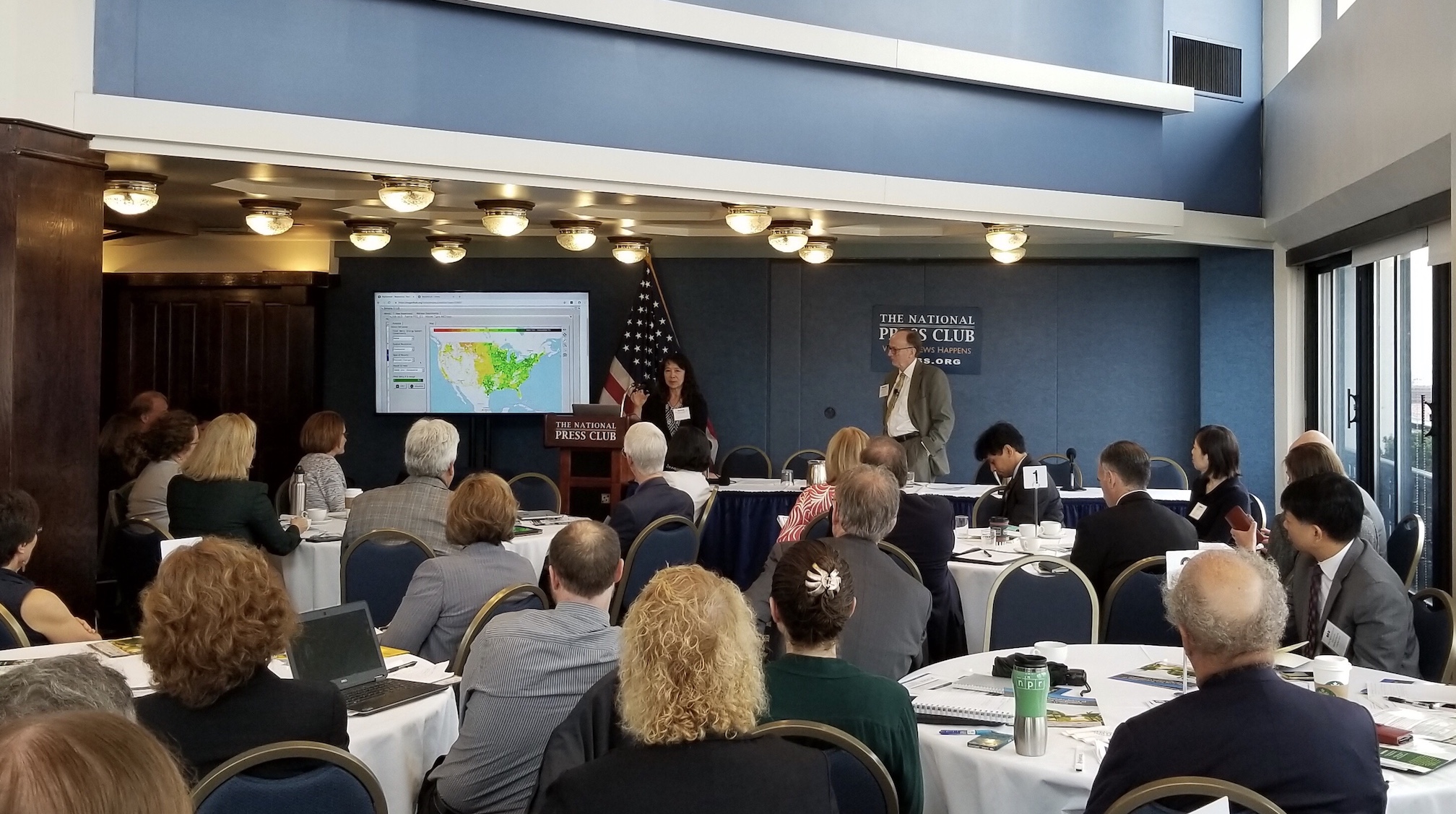
September 17, 2018 - MyGeoHub in action at the "Long Run Sustainability of U.S. Agriculture Conference" at the National Press Club, Washington D.C.
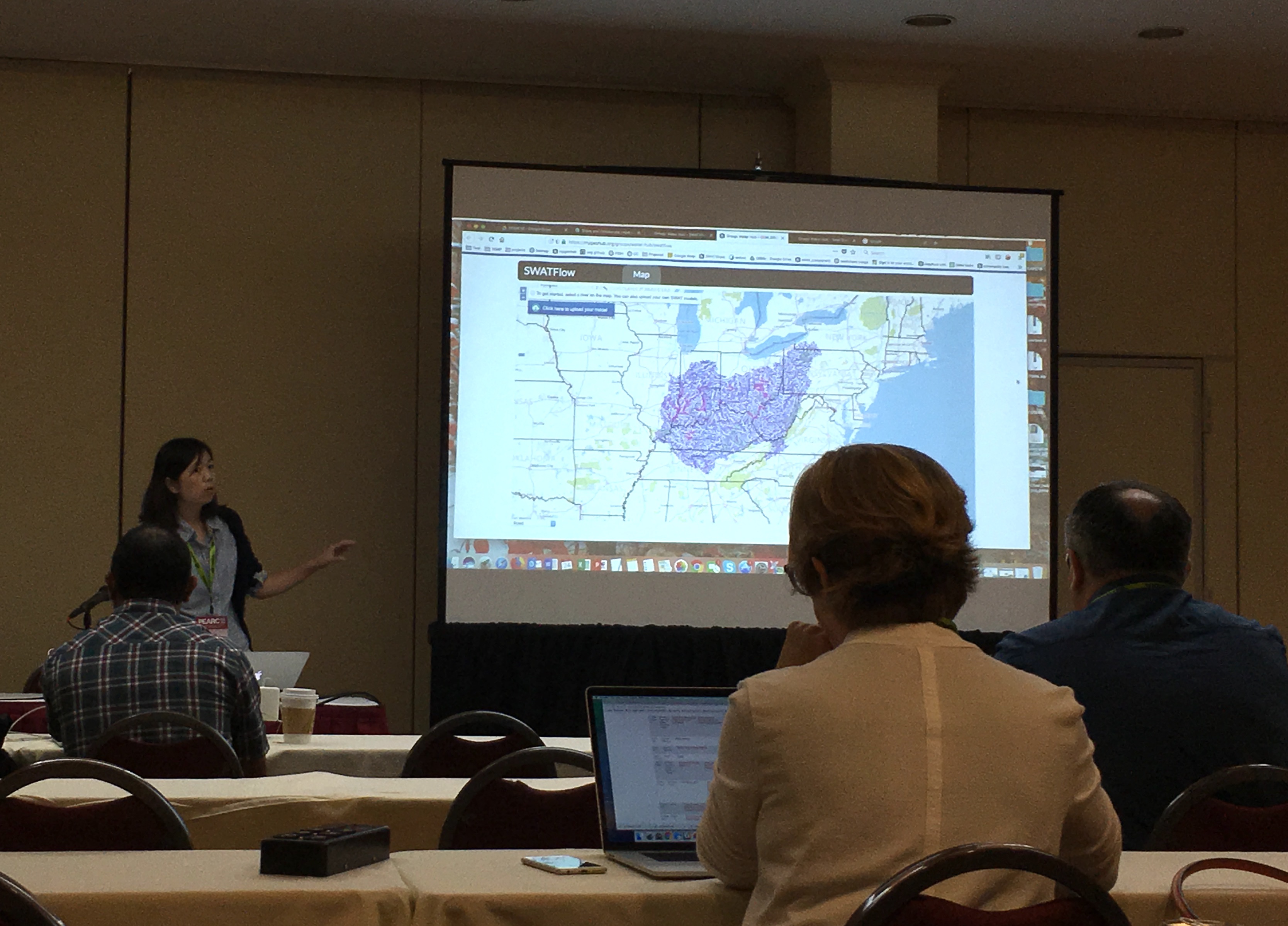
July 2018 - presenting at PEARC18 conference (Practice & Experience in Advanced Research Computing)

September 13, 2017 - Internships in ITaP Research Computing’s Scientific Solutions Group boost student success
July 26, 2017 - Two ITaP Research Computing teams win awards at national conference
July 7, 2017 - ITaP staff presenting at advanced research computing conference
July 5, 2017 - Students learn about geospatial data analysis, virtual reality through Research Computing summer outreach
Newsletters
Scientific Solutions in Byte Size, May - July 2018
The group is excited about a number of newly funded projects, including:
- The phase 2 of the GABBs project to provide seamless connections among platforms, data and tools, making large scientific and social geospatial datasets directly usable in scientific models and tools funded by the CSSI Framework program as a $4.5M, 5 year effort with multiple partners and collaborators (PI Carol Song, CoPI: V Merwade, J. Jin, U Baldos, J Smith);
- A 3-year NSF Scholarship for Service (SFS) Capacity grant to develop CHEESE (Cyber Human Ecosystem of Engaged Security Education) led by Prof. Baijian Yang and Dr. Rajesh Kalyanan, a collaboration between Purdue, NCSA and SDSC. CHEESE will utilize the National Data Service (NDS) Labs Workbench platform to host community-developed containerized demonstrations of cybersecurity concepts.
- A 3-year CyberTraining grant with Profs. Merwade and Huber “Training next generation of interdisciplinary researchers in Findable, Accessible, Interoperable, and Reusable (FAIR) science” using tools on MyGeoHub and elsewhere;
- A grant with Prof. Shweta Singh (ABE) to develop a “A Novel Approach to Reproducible, Transparent and Fast regional PIOT Development Via Collaborative PIOTHub” to be hosted on MyGeoHub.
- Another CSSI proposal (CoPI Rajesh) is still in pending status.
- Carol and Lan worked with Prof. S. Singh on a cyber physical proposal, also in pending status.
Our DURI intern student Ya-Wen Chu successfully completed her work with us for the spring 2018 semester (supervisors: Lan, Jungha). She presented a poster about her work at the DURI student conference in April.
PEARC18 - Several from the group presented at the conference. The activities include:
- Lan Zhao presented a showcase titled “Developing a Collaborative Hydrological Modeling Platform” highlighting the workflow that can be created online using SWATShare, SWATFlow, and HydroGlobe.
- Larry presented our GABBs work with the TOTAL camp in a paper titled “Introducing Research Concepts to Middle School Students via a Geospatial Science Gateway”.
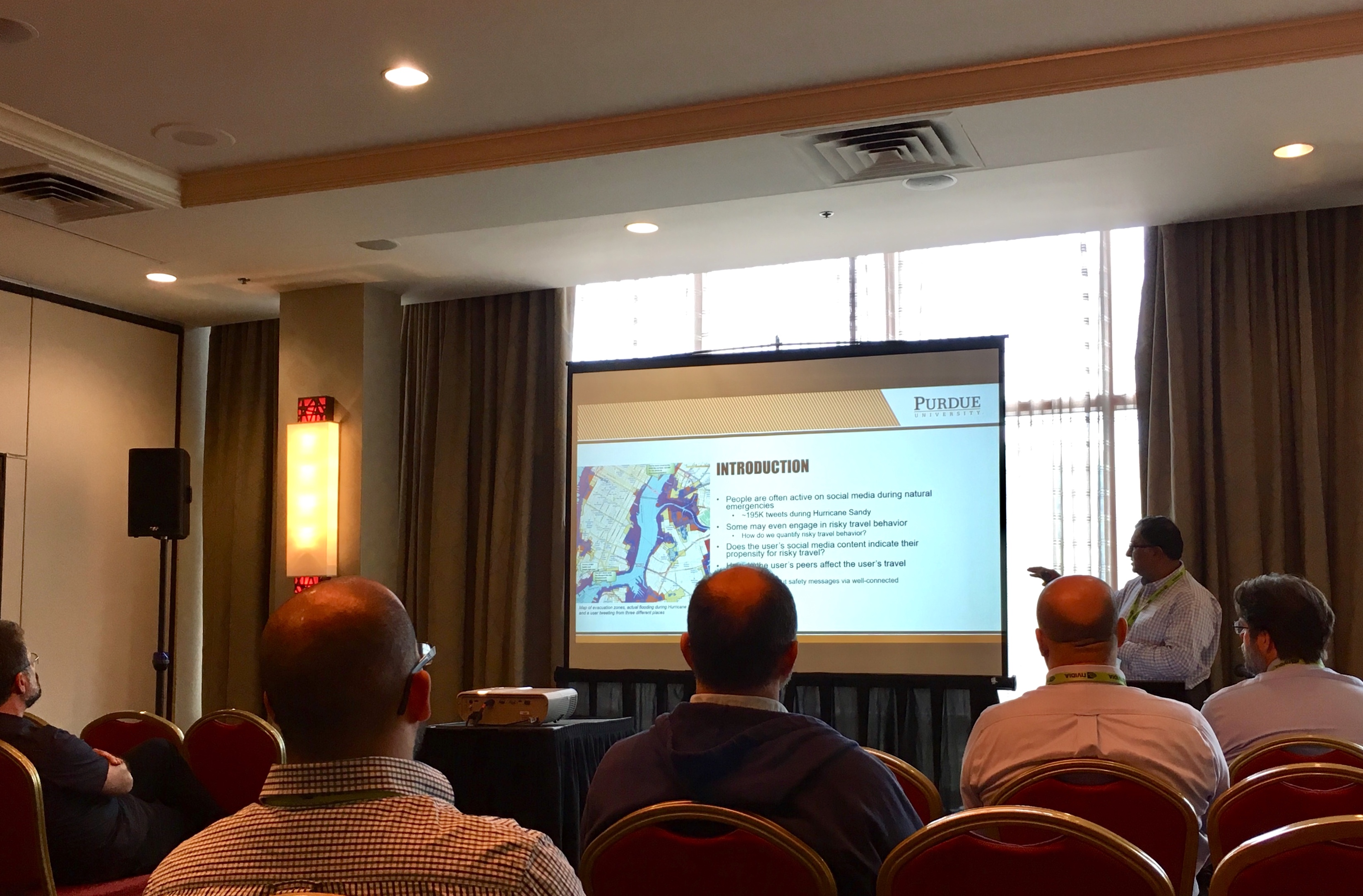
- Rajesh presented his work with Sorin Matei from Purdue’s School of Communication titled “Social Media Modeling of Human Behavior in Natural Emergencies”.
- Jaewoo Shin presented a student poster titled “A Flexible, Cloud-based Sensor Data Service Platform”.
- MyGeoHub was the most popular of the several science gateways used in the SGCI Hackathon held at PEARC18. Rajesh mentored a team of students that worked on a Jupyter notebook interface to track active weather events and process the public Twitter stream to generate a word cloud of tweets.
Other engagements include:
- Larry presented a poster at the Indiana GIS Conference in Ft. Wayne, IN during May 9-11, about IndianaView and made several fact sheets available. A poster about MultiSpec Online on MyGeoHub by Wei-Kong Hsu won 3rd place in the student poster competition.
- On the Arequipa Nexus Institute project, Larry is preparing material for a remote sensing workshop as one of 10+ workshops for 24 visitors from UNSA in Arequipa, Peru.
- Chris and the HUBzero team's Steve Clark are co-authors on a paper accepted to the upcoming Gateways 2018 conference in Austin, TX. Researchers at Iowa State University developed PolyRun to explore polymer microstructure modeling on local research clusters, but they needed the help of XSEDE to find a larger audience. The paper details the history of PolyRun and the Extended Collaborative Support Services (ECSS) project within XSEDE to deploy it on the Purdue DiaGrid platform. The XSEDE community can now use the program on DiaGrid where it submits work to the Comet cluster at SDSC.
- Lan and Jungha’s paper titled "Experiences in Optimizing Geospatial Data Processing for Isotopic Landscape Modeling" was accepted to the Gateways 2018 conference in Austin, TX. This paper describes the design and implementation of geospatial data processing to support isoscape modeling and prediction in the IsoMAP gateway as part of the ORIGIN project funded by NSF. ORIGIN consists of two integrated platforms that together provide the data resources, analytical tools, and project support necessary to streamline the analysis of data from migratory animal samples.
We continue to be involved in community efforts related to sustainable research software and the future CI ecosystem. Carol participated in the NSF OAC workshop “Rethinking NSF's Computational Ecosystem for 21st Century Science and Engineering” in May, and the Geospatial Software Institute conceptualization workshop #2 in Chicago, in July. Lan and Venkatesh represented the GABBs project the NSF DIBBs 2018 PI meeting in D.C., in July. Carol also presented the interoperability work we have done in the GABBs project at the International workshop on science gateways in Edinburgh, UK, in June.
Scientific Solutions in Byte Size, March - April 2018
It’s been a very hectic March/April for the solutions group, and looks like we will have much to share in the upcoming conferences and perhaps more good news to share in the coming months.
IWSG 2018
A lightning talk abstract titled “Challenges and Experience in Enabling Science Gateway Interoperability - A Case Study of MyGeoHub” by Lan, Rajesh and Carol was accepted for presentation at the International Workshop on Science Gateways (IWSG) in June, 2018.
PEARC 2018
Our paper “Introducing Research Concepts to Middle School Students via a Geospatial Science Gateway” was accepted for PEARC 2018. This paper describes the experience by Larry Biehl, Lan Zhao, Carolyn Ellis, Rajesh Kalyanam, Robert Campbell, and Carol Song in giving middle school students a geospatial experience using the MultiSpec Online and Geobuilder tools on MyGeoHub.
Our paper “Social Media Modeling of Human Behavior in Natural Emergencies” was accepted for PEARC 2018. This paper describes work by Rajesh, Lan and Carol in conjunction with Professor Sorin Matei (Brian Lamb School of Communication) to build a platform to process and analyze tweets and risky travel behavior during extreme weather events.
The group has submitted two NSF CSSI proposals in collaboration with Purdue faculty and researchers from other institutions. One is a follow-on to GABBs, focusing on expanding its ability to connect to diverse data sources and interoperate with other cyberinfrastructure and platforms. The second one focuses on building a urban data and modeling data infrastructure.
Website Updates
MyGeoHub.org and the GABBs Project website are in the process of being updated. Specifically, MyGeoHub.org is undergoing some minor changes to eliminate unused menu items, reduce redundancy, and make news and social media more visible. The GABBs Project website will receive a complete facelift in the coming weeks, including general design and color scheme as well as a more focused approach to highlighting the project’s accomplishments. Also in the works for the GABBs Project is a marketing postcard designed to provide basic information about the project, contact information and highlighting key resources and accomplishments. This postcard will be used for outreach efforts at various conferences, meetings and other networking opportunities.
Arequipa Nexus Institute
Scientific Solutions is involved with a joint Purdue - Universidad Nacional de San Agustín, Peru (UNSA) initiative called the ‘Arequipa Nexus Institute’ (https://www.purdue.edu/discoverypark/arequipa-nexus/en/index.php). SSG's Larry Biehl is providing remote sensing data support for the Sustainable Water Management project led by Laura Bowling which is one of 10 funded projects.
Scientific Solutions in Byte Size (Jan - Feb 2018 issue)
As we zip through the first two months of 2018, here is a brief summary of the going-ons and early accomplishments.
Quick bytes
- Some of us joined the rest of the campus in two exciting recent events: Women Who Get IT and Women in Data Science inspiring students toward careers in IT and data science (Carol participated in two panel discussions).
- Submitted a science data management tutorial to PEARC18, a collaboration with Purdue Libraries and NCSA.
- 5 other PEARC18 abstract submissions have received go-aheads - march on to the next deadlines!
- The MyGeoHub paper to the journal of Future Generation Computer Systems has been accepted for publication! A copy can be accessed here.
- We collaborated with faculty and colleagues at RCAC in recent three proposals
- Cyber training with Profs Merwade, Huber, Feb 14
- Campus CI network improvement proposal led by RCAC, Jan 30
- NIH proposal resubmission with Profs. Hennes and Lane, Feb 5.
CRI - FRESCO - A new repository of Conte performance data from the CRI project was published by Rajesh at https://www.rcac.purdue.edu/fresco/. A paper was submitted to HPDC (contributions from Rajesh, Stephen H, and Carol).
Geospatial Software Institute conceptualization first workshop - Our position paper, co-authored by Lan, Rajesh and Carol, to the workshop was accepted. Carol attended the workshop and served on a panel, Jan 28-30, 2018, Los Angeles.
GLASS - the Big Idea project: Two stakeholder workshops were held in January, Carol and Lan participated. The project received feedback on a broad range of issues, primarily on how to engage the sustainability research and policymaking communities. The project plans to hold a stakeholder workshop at the National Press Club in September 2018 where MyGeoHub will be used for demonstrations and hands-on activities.
Scientific Solutions in Byte Size (November - December 2017 issue)
We continue to be busy and productive throughout the final two months of 2017. Here is a list of highlights.
AGU Fall Meeting, December 11-15, 2-017 --- AGU is the last conference we participated in 2017, and the SSG had multiple posters/presentations (some in collaboration with our domain science colleagues):
- MultiSpec: A Desktop and Online Geospatial Image Data Processing Tool, oral presentation by Larry Biehl (slides available at: https://mygeohub.org/resources/1385 )
- MyGeoHub: A collaborative geospatial research and education platform, poster, Rajesh Kalyanam et al
- A New Cyber-enabled Platform for Scale-independent Interoperability of Earth Observations with Hydrologic Models, poster, Lan Zhao, Adnan Rajib, Venkatesh Merwade, Jaewoo Shin, Jack Smith and Carol X Song
- Transforming SWAT for continental-scale high-resolution modeling of floodplain dynamics: opportunities and challenges, poster, presented by Adnan Rajib and Venkatesh Merwade.
- Systematic losses of outdoor production from heat stress and climate change, poster, presented by our collaborator in the GLASS project Jonathan Buzan.
PEARC18 Submissions
Although PEARC18 won’t convene until July 2018, we got busy early as the submission process was changed to include a first round of abstract submission by December 8. The SSG team has made the following submissions:
- Tutorial abstract: A Primer on Online Research Data Management and Collaboration (plan to collaborate with Purdue Libraries and NCSA’s Brown Dog team)
- Paper abstract: Streamlining Geospatial Data Processing for Isotopic landscape modeling
- Paper abstract: Using Science Gateway for Middle School Student Geospatial Technology Camp Experience
- Paper abstract: Social Media Modeling of Human Behavior in Natural Emergencies
- Showcase abstract: Showcasing a Collaborative Hydrological Modeling Platform
- Poster abstract: A Flexible, Cloud-based Sensor Data Service Platform (student submission)
SGCI Marketing Sessions --- Marisa, Carolyn and Carol met with marketing expert, Claire Stirm from Hubzero, in a series of four strategic planning marketing and media mini-workshops. The team learned about marketing tools and develop strategies that will be implemented in the outreach efforts for MyGeohub.org. Details of the plan are being worked out, with a few items having been implemented already – follow our new accounts (GABBs Project and MyGeoHub.org) on Twitter!! You’ll hear more about our marketing plan and implementation in 2018.
Climate Scenario Aggregator (CSA) --- The CSA is an interactive online tool for “Web-based access, aggregation, and visualization of future climate projections with emphasis on agricultural assessments” that has been used by more than 30 users for 380 data downloads to date. Our team developed the tool in collaboration with Dr. Villoria at KSU (formerly Purdue), Dr. J Elliott at University of Chicago, and Dr. Christoph Müller at Potsdam Institute for Climate Impact Research (PIK). Jaewoo, Lan and Carol are co-authors of a paper on CSV recently published in the journal of SoftwareX (available at https://doi.org/10.1016/j.softx.2017.11.004).
On the proposal and grants front, congrats to Rajesh on completing his second NSF proposal! He is Co-PI on a cybersecurity training/education proposal with Prof. Baijian Yang (PI), and was able to establish a collaboration between Purdue, NCSA (NDS) and SDSC (Big Data Hub) for this proposal.
Larry Biehl is part of the Arequipa Nexus Watershed Management project led by Prof. Laura Bowling which is to start in January 2018. Larry will work with Prof. Keith Cherkhauer to identify remote sensing geospatial products to be used for watershed management in the Arequipa region of Peru. The project is a part of joint Purdue - Universidad Nacional de San Agustin (UNSA) partnership (http://www.purdue.edu/newsroom/releases/2017/Q4/purdue,-peruvian-university-enter-into-research-and-innovation-alliance.html).
Scientific Solutions in Byte Size (Setempber 1 - October 31, 2017 issue)
It’s been a fruitful fall season for the scientific solutions team - we have been active in several conferences while making progress in our ongoing projects.
First, congratulations to Rajesh for being named Young Professional of the Year by the Science Gateways Community Institute (SGCI) in recognition of his work on multiple science gateways including the GABBs project most recently. A well-deserved award for Rajesh!
Presentations at Gateways 2017
Several from the team participated in the conference last week at U of Michigan. Rob presented our latest work on extending GABBs to work with field data collection via mobile apps (paper and slides). Rajesh demonstrated how a science project could utilize GABBs geospatial data management and workflow features (paper and slides). The team also had discussions with interested projects around its poster at the conference.
Abstracts to AGU accepted
All of our submitted abstracts have been accepted for presentation at the AGU Fall Meeting 2017 in New Orleans! Larry will give a talk on the MultiSpec online tool. Rajesh will present a poster on the MyGeoHub geospatial gateway. Our collaborating scientist Adnan in civil engineering will present a poster on helping hydrologic modellers prepare earth observation data using HydroGlobe, an application that we have developed on MyGeoHub.
GABBs@SGCI Bootcamp, October 2017
Carol and Carolyn attended the weeklong bootcamp with GABBs as the project focus with a cohort of other Science Gateways professionals. Topics included many of the business related items that come with launching a successful product within the available opportunities in the current market. Topics included: defining the value proposition, understanding the current & growth audience, determining market fit, goal setting, budgeting, technology selection, outreach with your product, long term sustainable funding models, and developing meaningful metrics around these objectives. It was a great week - we came out with tools and a pitch deck, as well as new connections to people through networking at the bootcamp.
The GLASS project & Impacts World conference
The GLASS project (DP Big Idea) is taking off with lots of activities. GLASS is hosted as a supergroup and featured prominently on the homepage of MyGeoHub. The web site has been launched and is being continuously updated with new contents and tool releases. As the first major development milestone, Jungha integrated policy impacts modeling into the SIMPLE-G tool. The new functions supports research on the impacts of policy interventions in different geographic regions on food security. The release was in time for the GLASS team’s presentations at the Impacts World 2017 conference where Carol Song and other members of the GLASS team joined more than 450 participants from 68 countries in Potsdam, Germany to discuss challenges and solutions in climate-impacts research. Carol gave a presentation titled "An opensource geospatial cyberinfrastructure for interdisciplinary collaboration and broader engagement" (slides) on the scientific applications enabled by MyGeoHub and the geospatial building blocks software. The capabilities demonstrated through SIMPLE-G attracted quite a bit of attention, including requests to host additional tools, workflow and datasets, and opportunities for future collaborations.
IndianaView/AmericaView
The project to create Landsat thematic mapper data sets for each of the counties in Indiana was completed: http://www.indianaview.org/glovis/IN_County_Landsat_Data.html. The data sets represent a temporal sampling across 30 years for each of the counties. The data were obtained by Landsat 5 and also the most recent Landsat 8 sensors. These data sets were prepared to make it easier for teachers, students and the public to view and analyze Landsat images of their areas without have to download and manage full Landsat (~15 county scenes).
AmericaView sponsored an official Earth Observation Day (October 10) during Earth Sciences week. As part of this event, a poster was prepared by NASA/USGS/AmericaView about Landsat data including a Candyland type game; see Larry if you wish to have one. Also as part of this event, Larry prepared an online puzzle allowing the user to select many different images from Landsat data for the puzzle:http://indianaview.org/image_puzzle.html.
Grant proposals
The group worked with Prof. Shweta Singh of Environmental and Ecological Engineering and ABE, Purdue, and submitted a proposal aimed at creating an innovative, collaborative platform for developing and standardizing process modeling to help solve issues in a circular economy (e.g., recycling). Two other proposals are in the works.
Scientific Solutions in Byte Size (August 2017 issue)
The new semester has creeped up upon us before we know it! Looking back on August, we have quite a bit to share.
Recent articles on:
- The student interns mentored by the SSG staff
- TOTAL Camp students learning about geospatial data and visualization
GABBs project awarded supplemental funding
Great news for the GABBs team this month! The project has been awarded a supplemental award from the NSF. The project has now been extended to its fifth year. While the project will continue to support the broader community through its software releases and MyGeoHub, this supplement enables the team to reach new user communities; partner with experts at Carleton College to develop education modules using GABBs-enabled tools; provide summer undergraduate research experience; increase interoperability including expanded metadata support and working with RENCI’s hydroshare team to launch GABBs tools. As part of this supplement, we are excited to welcome Marisa Brazil to join the team to expand our engagement effort!
GABBs@SGCI Bootcamp, October 2017
The GABBs team applied and has been accepted to participate in the upcoming Science Gateways Community Institute’s Boot Camp during the week of October 2. Carol and Carolyn (PI and Program Manager of the project) will be at the workshop. The goal is to get help in developing a sustainability plan, including marketing and engagement ideas and tools.
Gateways 2017 submissions accepted
Two submissions to the Gateways 2017 conference have been for presentation. Rob Campbell is the lead author of a short paper titled “Extending Gateways into the Field: Geospatial Extensions and Remote Data Services”. Rajesh led the “Demo: MyGeoHub Science Gateway” submission. Both have been accepted through a peer review process. The group also submitted a poster about the GABBs project -- a good tool to engage the audience and advertise our presentations.
Research Data Management Implementation workshop
Carol, Preston and Alex Younts co-authored a white paper to the upcoming RDMI workshop September 14-15, titled “creating a seamless campus cyberinfrastructure to support data-driven domain science”. Carol and Preston will attend the workshop. For reference, all papers submitted to this year’s workshop can be accessed at https://rdmi.uchicago.edu/papers.php.
New grant proposal submitted to NSF
Rajesh led the development of a new proposal in collaboration with Prof. Sorin Matei. This work built on the pilot project of establishing a social media data collection, processing, and visualization pipeline with geospatial data support, and focuses on the modeling of risk behavior during natural emergencies. The proposal was submitted to a program in the NSF SBE directorate.
AGU submissions
Rajesh and Larry submitted abstracts for the 2017 AGU Fall Meeting titled MyGeoHub: A collaborative Geospatial Research and Education Platform” and “MultiSpec: A Desktop and Online Geospatial Image Data Processing Tool”, respectively.
Geospatial Software and License Server Updates
Recent software updates for ArcGIS Pro, ArcGIS Desktop, and ENVI were made available for the campus to be ready for the Fall semester. License servers were also updated. (https://www.rcac.purdue.edu/downloads/geospatial/).
Scientific Solutions in Byte Size (June-July 2017 issue)
TOTAL Camp
When their teachers ask what they did this June 11-14, the students in the Purdue Polytechnic Institute’s Turned Onto Technology and Leadership (TOTAL) camp will have a good answer – they spent a portion of the week learning about geospatial data with GABBs team. Using MyGeoHub’s MultiSpec image processing tool, TOTAL campers completed a hands-on exercise employing satellite imagery to calculate how much land had been impacted by a flood. This hands on session was lead by Larry Biehl with help from other GABBs team members.
HUBzero / GABBs ½ day Tutorial at PEARC
This tutorial organized around the recently added Jupyter and R Studio tools on HUBzero went smoothly and the hands-on exercises worked great on MyGeoHub. Martin Hunt, Derrick Kearney, Kevin Wojkovich and Rajesh presented the hands-on components and Carolyn lead the efforts to keep the teams coordinated. Thanks to the effort put in by the teams prior to the conference! This presentation has resulted in at least two inquiries of collaboration - potential new hub and hosting, and GABBs geospatial tutorial for high school students.
GABBs Packaging Session at PEARC
A paper on our experiences in moving GABBs to AWS was presented at the PEARC17 conference by Rajesh. AWS CloudFormation is now employed to enable a completely automated installation and configuration of GABBs, which includes a hub instance and other complementary software and servers. For more details, check out the GABBs release page: https://mygeohub.org/groups/gabbs/release.
MultiSpec Poster winning Student Category
Wei-Kang Hsu, graduate student working with Larry Biehl on MultiSpec Online, presented a poster about this work at PEARC17. His poster won the “People’s Choice Best Student Poster” Award. MultiSpec is a freeware image processing tool to analyze a broad spectrum of geospatial image data, with capabilities such as feature extraction, feature enhancement, supervised and unsupervised classification, and multi-dimensional data visualization.
GABBs presented at the IWSG
The GABBs development and outcomes were presented at the 9th International Workshop on Science Gateways, June 19-21. A pre-print draft of our paper can be found at https://mygeohub.org/resources/1318. It was a good opportunity to connect with researchers working on getaways and relevant technologies on both sides of the Atlantic and increase awareness of similar work going on in other groups (e.g. international consortium on science gateways). The other good news is that the tools on MyGeoHub ran quite well with good performance when Carol attempted them in Poland.
TryCybSI paper to ACM SIGITE accepted
A paper describing the TryCybSI cybersecurity learning and demonstration platform has been accepted to the ACM SIGITE (Special Interest Group for IT Education) conference, Oct 4 - 7, Rochester, NY. TryCybSI uses the AWS ECS service and Docker to scalably spawn containerized cybersecurity applications on-demand. TryCybSI was funded by the IEEE Cybersecurity Initiative and has been used in an undergraduate class in the Purdue Polytechnic Institute. Contact Rajesh for more details on this paper and project.
Previous work on NEES published
A paper titled “A Researcher-oriented Automated Data Ingestion Tool for Rapid Data Processing, Visualization and Preservation” has been accepted for publication in the journal of Advances in Engineering Software (lead author: Tom Hacker). This paper details a tool development within the Purdue-led NEES project to perform live monitoring of remote experimental sensors and collecting multiple video feeds from a HUBzero science gateway (e.g. neesHUB). Chris Thompson consulted in in the development of this program and is a co-author of the paper.
Abstract to Impacts World 2017 conference accepted
An abstract titled “An open source geospatial cyberinfrastructure for interdisciplinary collaboration and broader engagement” has been accepted to one of the workshops at the conference: “Universities as catalysts for change and community building around the Sustainable Development Goals”, to be held in mid October. This work is part of the Big Idea project on long term food sustainability.
Proposals submitted
June - July have been a busy time for SSG! We partnered on several proposals, including:
- An NIH proposal on developing a generalized framework and software environment for power analysis with Purdue Psychology faculties (using DiaGrid)
- An AFRI proposal on fostering agriculture resilience in the face of increasing climate variability (PI Tom Hertel)
- GABBs supplemental request (PI Carol Song), including work with RENCI on interoperability with Hydroshare CI and Carleton College on developing a new education module based on HydroGlobe (a new tool on MyGeoHub).
Scientific Solutions in Byte Size (May 2017 issue)
GABBs paper to IWSG 2017 accepted
A GABBs overview paper has been accepted by the 9th International Workshop on Science Gateways, June 19-21, 2017 in Poland. Titled “GABBs - Reusable Geospatial Data Analysis Building Blocks for Science Gateways”, the paper is co-authored by Lan Zhao, X. Carol Song, Rajesh Kalyanam, Larry Biehl, Robert Campbell, Leif Delgass, Derrick Kearney, Wei Wan, Jaewoo Shin, I Luk Kim and Carolyn Ellis. A draft version can be found on MyGeoHub.org (link).
DiaGrid and XSEDE OAuth integration poster at PEARC17
Our poster, titled “Integrating XSEDE OAuth 2.0 with the DiaGrid Science Gateway” has been accepted to the PEARC17 poster session. This poster describes the use of XSEDE OAuth 2.0 authentication/authorization server to enable XSEDE users to log in to DiaGrid, and the lessons learned from this work. This integration allows XSEDE users of various levels of expertise to get instant access to a diverse set of software and resources, and a platform to publish interactive scientific applications. Jungha will present the poster at PEARC17.
SIMPLE-G published on MyGeoHub
A new tool, SIMPLE-G, has been released on MyGeoHub.org. This is a multi-region, partial equilibrium model of gridded cropland use, crop production, consumption and trade, extended from the SIMPLE model, allowing incorporation of explicit local environmental constraints in its projections at grid cells. Lan and Jaewoo worked with Ag Economics researchers in creating a user interface for the web version of the tool and integrated a Linux version of the SIMPLE-G into MyGeoHub.
USDA/Mellon/Big Idea project meetings in May
The Solutions group staff presented MyGeoHub and their recent work on the SIMPLE-G modeling tool at the meeting. The presentation covered the state of the MyGeoHub, including its tools and capabilities with the recently deployed GABBs software, R Shiny and Jupyter. The highlight of the presentation is a live demonstration of the SIMPLE-G tool that inspired extensive discussions on how it could be used and extended as it underpins several related projects.
PEARC17 HUBzero Tutorial getting in shape!
The scientific solutions and HUBzero teams are partnering to create this year’s HUBzero PEARC17 tutorial. Responding to feedback from the reviewers, the teams are shaping this into a more cohesive tutorial, e.g., slimmed down the content by using common datasets and examples, to provide clear learning objectives and better engage the attendees.
SDSC’s Summer Institute
Rajesh has been accepted to attend the SDSC’s Summer Institute on HPC and Data Science. This week-long workshop in July-August will include instruction and hands-on training in using SDSC’s HPC resources, modern container and workflow technology and machine learning libraries for data science.
Indiana GIS Conference
Larry presented a poster on IndianaView/AmericaView at the Indiana GIS Conference held at the Monroe County Convention Center in Bloomington, IN on May 9 and 10. Several fact sheets were made available about IndianaView/AmericaView, the minigrant and student scholarship programs, and MultiSpec.
Geospatial Software
The latest version (5.4/8.6) of ENVI/IDL was made available for campus use during May.
Scientific Solutions in Byte Size (April 2017 issue)
PEARC17 Tutorial Accepted
A joint tutorial proposal from the SSG and HUBzero teams has been accepted to the PEARC17 conference. A half-day tutorial, titled “Interactive Science and Geospatial Visualization Tools for HUBzero Science Gateways”, is scheduled for Monday afternoon, July 10, at the PEARC17 conference in New Orleans. The tutorial will include presentation and hands-on exercises on creating tools in the newly integrated interactive tool environments (e.g., Jupyter, R Shiny) and built-in geospatial capabilities from the GABBs project. The tutorial team includes: Rajesh Kalyanam, Derrick Kearney, Michael Zentner, Betsy Hillery, Lan Zhao, Carolyn Ellis, and Carol Song. (schedule info) (Contact: Rajesh)
PEARC17 GABBs paper accepted
A paper titled “Cloud-enabling a Collaborative Research Platform: The GABBs Story” describing the packaging of GABBs components for deployment on AWS has been accepted to the PEARC17 Software and Data track (Rajesh as the lead author). The paper describes the use of AWS CloudFormation templates to declaratively specify the various AWS resources, software installation and configuration tasks for automatically creating a GABBs-enabled HUBzero hub on AWS. (Contact: Rajesh)
New Crop Model Evaluation tool deployed in MyGeoHub
The Global Gridded Crop Model Evaluation toolis the latest new tool added to MyGeoHub.org. This tool supports comparison of crop model simulation results with community reference data sets at various scales (global, national and grid cell levels). This tool was developed in collaboration with researchers at PIK (Potsdam Institute for Climate Impact Research, Germany). PIK researchers provided the scripts for data processing and we created a user interface using the Python map library (pymaplib) from the GABBs project and integrated the GCCM into the hub. (Contact: Lan, Jaewoo Shin)
IsoMAP2 gateway deployed
With 1600 registered users worldwide, IsoMAP is an online workspace for spatial analysis, modeling and prediction of stable isotope ratio variation in the natural environment. IsoMAP consists of a suite of web-based GIS and software tools allowing users to easily explore, develop, and implement models for isotope distributions. The first version of IsoMAP portal was based on the Gridsphere framework which is no longer being maintained. The IsoMAP portal has been migrated to the Spring Java framework with improved functionality. The new portal was released in production in April. With the new phase II funding from NSF, new features will be created to support research on bird migration using isoscapes modeling (http://isomap.org). (Contact: Lan, Jungha)
HazardSEES project
Chris started consulting on the EvacSim project within the HazardSEES NSF program (PIs: S.V. Ukkusuri, Civil Engineering, M. Kulkarni, ECE) in April. This project investigates simulation of vehicular traffic in an urban area and, ultimately, helps decision makers plan and manage during emergency evacuations. Chris’ current role is to develop the communication protocol between the model and visualization programs so users can monitor the simulation real-time. He will also advise on software development best practices to help improve the simulation software developed to date by the group’s graduate students. The group currently tests the model with evacuation traffic patterns of Miami using 40,000 vehicles but hope to scale this to a more realistic 300,000 vehicle simulation before generalizing the project to handle other metropolitan areas. (Contact: Chris, Carol)
U2U Project
The U2U project (https://mygeohub.org/groups/u2u) was successfully completed on April 14. The decision support tools that several Scientific Solutions staff have worked on during the past six years have been moved to the Midwest and High Plains Regional Climate Centers as permanent homes. The current version of the U2U tools, which will continue to be available on mygeohub for the next year or so, have been updated for the 2017 growing season. For a nice summary of the project, check out the U2U page! (Contact: Larry)
Scientific Solutions in Byte Size (March 2017 issue)
DP Big Idea Challenge grant
SSG is part of a Discovery Park Big Idea Challenge winning team led by Professor Tom Hertel in a project for “Managing the Global Commons: Sustainable Ag and Use of World’s Land and Water Resources”. We will develop and integrate global-gridded crop model SIMPLE-G on MyGeoHub.org and work with a multidisciplinary team on dissemination and training. Carol serves as CoPI and will lead the CI part of the project. The project will be for two years, starting in May. The announcement can be found here.
Mellon Grand Challenge grant
Another related grant awarded recently is from the Mellon Grand Challenge competition. Led by Professor Tom Hertel, the team includes researchers from political science, agronomy, ABE, library, and Research Computing, and is one of the four winning projects. Our role will be to support modeling, data analysis, as well as dissemination and workshops using MyGeoHub.org. The award is for 18 months, starting in Jan. 2017. More information can be found here.
U2U Cyberinfrastructure Paper Published
Larry, Lan, Carol and Chris (Panza) are co-authors on a newly published journal paper on the U2U cyberinfrastructure and decision support tools in the journal of Climate Risk Management (open access). This paper is the culmination of the CI development in this award-winning, five year USDA project. The PDF version of the paper can be downloaded at doi:10.1016/j.crm.2016.10.003. The project web site is at http://agclimate4u.org. An update of the U2U project in Purdue Today is here.
New MultiSpec Release
A new version of MultiSpec has been released in March (version 3.25.2017). The MultiSpec web page is:https://engineering.purdue.edu/~biehl/MultiSpec/. A description of the changes since the 2.8.2016 release can be found here. The MultiSpec Onlinerelease (358 users to date) contains almost all of the features that are in the desktop version. This version has been integrated with the GABBs data services. Contact Larry Biehl for more information.
Follow-up on RCAC Lightning Talks
SSG staff presented on two topics at the RCAC lightning talks recently. Rajesh discussed the IEEE TryCybSI project developing cyber security training platform in AWS (in collaboration with Polytechnic’s faculty Baijian Yang). Jungha Woo presented Karnak (wait time prediction) and his work to improve performance in Karnak 2.0 as part of an XSEDE development effort. Rajesh and Jungha welcome any additional questions and suggestions.
GABBs poster accepted for NDS7
Rajesh will attend the National Data Service workshop (co-located with GlobusWorld 2017) in Chicago, April 12 - 14 to identify interoperability ideas and partners. A poster describing the GABBs project has been accepted for the workshop’s poster session on April 12.