Example projects that the group leads and partners with researchers at Purdue and other institutions:
GABBs: Geospatial Data Analysis Building Blocks
GABBs is an NSF-funded DIBBs Implementation project to create a powerful W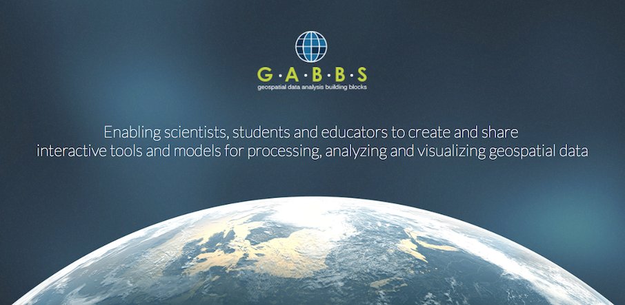 eb-based system that will allow researchers worldwide to manage, share, analyze and visualize geospatial data for purposes ranging from predicting damaging floods to projecting climate change effects on the poor. Phase 1 of the project (2013-2018) has created and deployed reusable software for geospatial data hosing, processing, visualizing, and sharing, integrated with Purdue's HUBzero platform. Phase 2 of the project (2018 - 2023) will provide seamless connections among platforms, data and tools, making large scientific and social geospatial datasets directly usable in scientific models and tools. This should open the way for easy development of a variety of Web-enabled tools for probing and presenting geospatial data in ways that can, among other things, help policymakers address pressing issues in the U.S. and around the globe.
Anvil: A new capacity high-performance computing system in XSEDE
Funded by the NSF Office of Advanced Cyberinfrastructure's Innovative Computing program, Anvil integrates a large-capacity high-performance computing (HPC) cluster with a comprehensive ecosystem of software, access interfaces, programming environments, and composable services to form a seamless environment able to support a broad range of current and future science and engineering applications. The Anvil system will be developed by Purdue's Research Computing (RCAC), and will be in production for five years starting in 2021 (news release resource information).
XSEDE: Extreme Science and Engineering Discovery Environment
Purdue is partner to this NSF funded national advanced computing and data cyberinfrastructure XSEDE, providing advanced support in performance optimization, community codes, scientific applications and science gateway development. Purdue is also leading the XSEDE Campus Champions program which has grown from one campus champion on one campus in 2005 to more than 580 champions from 290 campuses nation wide today. The Purdue XSEDE staff is knowledgable about the resources and allocation process, and can assist researchers in obtaining XSEDE allocations of computation cycles, data storage, and advanced support. (news)
DiaGrid - A Scientific Computing Platform and Service
 DiaGrid Hub is a science gateway that connects users to a powerful and diverse set of advanced computing resources (Purdue clusters, XSEDE systems) and helps the science community share resources, applications and collaborate with each other. It is free for users to sign up and access computing resources instantly. Based on the HUBzero and its virtualized middleware, DiaGrid supports scalable access to powerful computation resources through online tools, and is self-service – users may upload their own content – including scientific applications and tools, datasets, tutorials, courses, publications, etc., and share with other users, groups or publicly. Users may launch simulations and analyze results via an ordinary web browser without downloading, compiling, or installing any software. Tool developers can follow an automated process to create, install, test, and publish interactive tools on the DiaGrid web site. Computational tools on DiaGrid include bioinformatics (BLAST, BEAST, etc), simulations (GROMACS, NAMD, CryoEM, etc), visualization tools (ParaView, PyMol, etc) and general purpose computational tools such as IDEs with plugins for submitting jobs to HPC resources (e.g., RStudio, Spyder for Python, SubmitR for serial, parallel and parameter sweeps jobs, etc). DiaGrid.org also hosts science gateways for research groups.
GLASSNET: Developing a Global Network of Sustainability Research and Education
Funded by the NSF AccelNet program, this project creates a global network of scientific teams and research communities to work together and tackle sustainability issues related to land and water use across the globe. GLASSNET will act as a center without walls to break down global communication barriers through a synergistic mix of models, data, spatial scales, tools, disciplines, expertise, cultures, key regional test beds, and open access commitment to fill the SDG integration gap. Collaborators on the project are X. Carol Song (Purdue University); Matthew Huber (Purdue University); Stephen Polasky (University of Minnesota); and Danielle Grogan (University of New Hampshire). The team will focus specifically on the land- and water-related SDGs, including: SDG 1 No Poverty; SDG 2 Zero Hunger; SDG 6 Clean Water and Sanitation; SDG 12 Responsible Consumption and Production; SDG 13 Climate Action; SDG 14 Life Below Water; and SDG 15 Life on Land. (news release award info)
Superpower - Power Analysis Software Environment
SSG is partnering in a new NIH project that will develop a comprehensive and accessible online software for conducting statistical power and sensitivity analysis, one of the most significant steps to maximizing scientific reliability in health sciences. Drs. Erin Hennes and Sean Lane in the Purdue Department of Psychological Sciences are leading the project, titled "Toward a Generalized Framework and Flexible Software Environment for Power Analysis of Alcohol Treatment Randomized Controlled Trials". Our role in the project include the design and development of the Superpower tool, providing advanced computational and technical support to the researchers and students. The project site is currently at http://superpowertool.org.
Big Idea Challenge: GLASS (Global-to-Local Analysis of Systems Sustainability)
Our team is working with an interdisciplinary science team on a major new ![]() initiative addressing urgent issues related to meeting the United Nation's Sustainable Development Goals (SDGs). Funded by the Purdue's Discovery Park's Big Idea initiative, the GLASS project aims to establish an inter-disciplinary applied research consortium that facilitates and organizes a global community of practice around open-source analysis of the global-to-local-to-global (GLG) linkages underpinning the SDGs—and global sustainability more broadly. It represents an umbrella under which many different projects utilizing the GLG methodology are housed. Our team is partner to two other contributing projects to this effort, including a Mellon Challenge grant and an USDA project addressing the long run sustainability challenges in US agriculture.
initiative addressing urgent issues related to meeting the United Nation's Sustainable Development Goals (SDGs). Funded by the Purdue's Discovery Park's Big Idea initiative, the GLASS project aims to establish an inter-disciplinary applied research consortium that facilitates and organizes a global community of practice around open-source analysis of the global-to-local-to-global (GLG) linkages underpinning the SDGs—and global sustainability more broadly. It represents an umbrella under which many different projects utilizing the GLG methodology are housed. Our team is partner to two other contributing projects to this effort, including a Mellon Challenge grant and an USDA project addressing the long run sustainability challenges in US agriculture.
NSF INFEWS/T2: Identifying Sustainability Solutions through Global-Local-Global Analysis of a Coupled Water-Agriculture-Bioenergy System
To address the significant sustainability challenges faced by the global Food-Energy-Water System (FEWS), this project will develop and apply a novel integrated approach based on multi-scale, global-local-global analysis of coupled water-ag-bioenergy systems to identify and highlight the interactions of different policies or management activities and achieve a more complete understanding of how outside factors like economic or climate variability alter and constrain management decisions at local scales and influence national FEWS results. This project will establish a model coupling framework and process, and make this analysis system accessible to the broad FEWS community of researchers, students and decision makers. (NSF award information here)
CHEESE: Cyber-Human Ecosystem of Engaged Security Education
The CHEESE project funded by NSF's Scholarship for Service (SFS) Capacity program will develop a platform to host community-contributed containerizations of cybersecurity concepts. CHEESE will draw from prior experience with the IEEE TryCybSI project and utilize the National Data Service (NDS) Labs Workbench framework to deploy a publicly accessible cybersecurity education gateway. A significant component of the project will involve outreach efforts to user and contributor communities spanning high school students, teachers, undergraduate and graduate students, and cybersecurity professionals. CHEESE will utilize both campus and commercial cloud computing resources in its deployment and is a collaborative effort between Purdue, NCSA, and SDSC.
U-Cube: A Cyberinfrastructure for Unified and Ubiquitous Urban Canopy Parameterization
The U-Cube project funded by NSF's CSSI program will develop a cyberinfrastructure for computing, managing and utilizing urban canopy parameters (UCPs) for various cities around the world. UCPs can be used in various urban modeling and climate analysis tasks. The computation of UCPs leverages a novel inverse modeling approach for developing a 3D model of a city by utilizing satellite images, and urban zonal data among other data sources. U-Cube will leverage MyGeoHub for managing the geospatial data sources used in the UCP computation and developing novel tools that can utilize the UCP parameters. U-Cube will bring together urban planners, climate scientists and city officials around this cyberinfrastructure platform.
Cyber Training for FAIR Science
Funded by NSF's CyberTraining program, the overall goal of this project is to create a new generation of scientists to manage data-rich and computationally intensive tasks to become globally competitive in the STEM, thus fulfilling NSF's mission to promote the progress of science. It brings cyber-enabled state-of-the-art computational tools into practice by training students and working professionals through courses, workshops and boot camps at multiple institutions, including Purdue University, University of New Hampshire and University of Alabama. The project creates a cyber training curriculum that is driven by the need to acquire expertise in the following six areas: data access, geo-processing, time series analysis, computational simulation, visualization and publication. These areas form the foundation of a modular cyber training framework that supports the development and implementation of training materials targeting geoscience learners. The training component of the project will make the science openly available and transparently reproducible using the best practices in Findable, Accessible, Interoperable, and Reusable (FAIR) science.
Arequipa NEXUS Institute for Food, Energy, Water and the Environment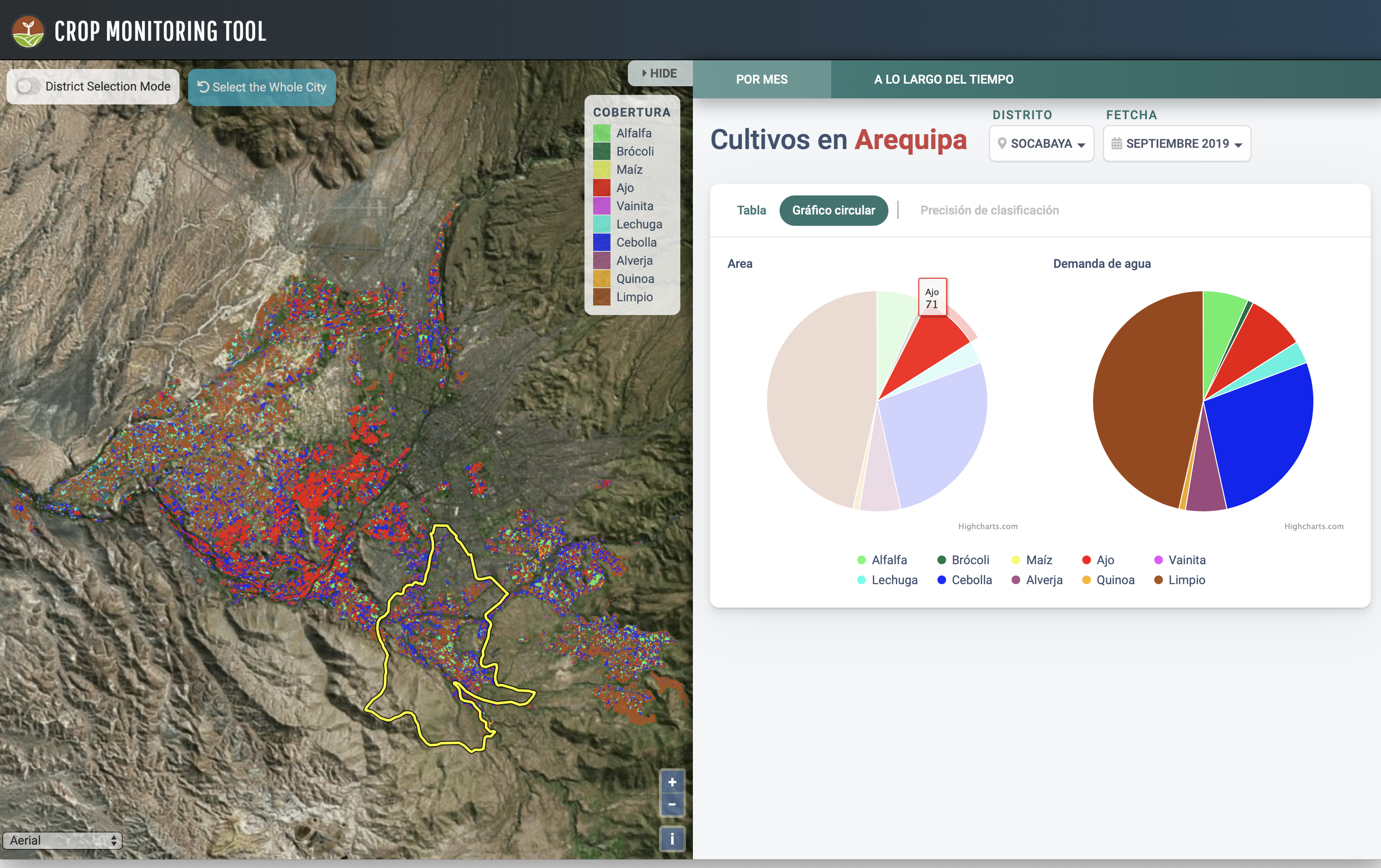
Purdue has started a new Cooperative Technical Alliance Program with the Universidad Nacional de San Agustin (UNSA) with the launch of its initial flagship research and capacity building initiative: the Arequipa Nexus Institute for Food, Water, Energy, and the Environment. Our research software engineers are developing several online tools for interactive data visualization and exploration for the study areas, including a crop data monitoring tool, a SWAT model visualization tool, and a climate data viewer for the regions in Peru.
The solutions group staff also provides expertise in remote sensing data to the sustainable water management component in this large project.
FRESCO: A Systems Data Repository for Dependability Research
This project aims at addressing a pressing need in the area of dependable computing systems: the lack of publicly available failure data from real (production) modern computing systems. The project will collect, curate, and present public failure data of large-scale computing systems in a repository called FRESCO. This project will also provide analysis tools to answer certain commonly occurring questions, such as the correlation between workload and failure and the performance implications of using one library over another, as well as an intuitive graphical front-end that will allow people to explore the data sets and download the relevant ones. This is a joint project between researchers at Purdue University and Univeristy of Illinois at Urbana-Champaign, funded by the National Science Foundation's CRI program. (project site). A second phase of the project is now funded by NSF CCRI program to integrate additional systems and usage information, especially the new NSF and campus systems, and establish a data ingestion pipeline for future datasets. This is a partnership between Purdue University and Texas Advanced Computing Center (TACC).
Online SWAT Modeling and Data Sharing
SWAT Modeling and Data Sharing tool on WaterHub provides an easy-to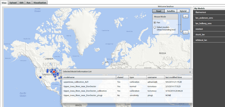 -use web interface that enables users to users to upload, share and edit their SWAT input data, run their uploaded model, download the output file, and visualize output results. WaterHUB is a global communication and research platform for research, education, knowledge sharing and global outreach. WaterHUB enables sharing of knowledge, data and modeling tools related to water. WaterHUB also exploits cluster computational resources for executing shared hydrologic models through high performance computing.
IsoMAP/ORIGIN
Funded by the NSF ABI program, IsoMAP is an  online workspace for spatial analysis, modeling and prediction of stable isotope ratio variation in the natural environment (isoscapes). IsoMAP consists of a suite of web-based GIS and software tools allowing researchers to access and integrate a number of disparate and diverse datasets, develop isoscapes models over selected spatio-temporal domains using geo-statistical algorithms, predict maps for the stable isotope ratios of water and plants, and associate a sample’s isotope value with its most likely geographic origin. Our team develops and operates the IsoMAP science gateway and supports research and training/education.
U2U - Useful to Usable
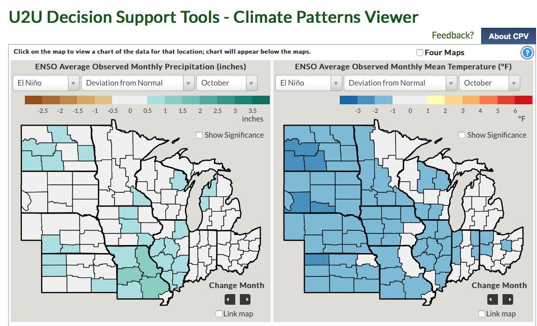
Useful to Usable (U2U): Transforming Climate Variability and Change Information for Cereal Crop Producers, is an integrated research and extension project that seeks to improve the resilience and profitability of farms in the North Central Region amid variable climate change through the development and dissemination of improved decision support tools, resource materials, and training. U2U will help producers make better long-term plans on what, when, and where to plant, and also how to manage crops for maximum yields and minimum environmental damage.
The Purdue version of the U2U tools are:
PhenoSorg - Purdue TERRA Project
The PhenoSorg project's full name is Automated Sorghum Phenotyping and Trait Development Platform. Purdue University’s team, along with IBM Research and partners, is acquiring and utilizing data to develop predictive models for plant growth and to design and implement sophisticated methods for identifying genes controlling sorghum performance. The team is creating a system that combines data streams from ground-based and mobile platforms for automated phenotyping. Advanced image and signal processing methods is extracting phenotypic information to produce predictive models for plant growth and development. The team is also using high-performance computing platforms and prediction algorithms to analyze and identify links between plant characteristics and their underlying genetics. The end goal is to develop a user-friendly system that will enable breeders and other end users to interact with the data and analytics. It is funded by the Department of Energy.
HazardSEES: Bridging Information, Uncertainty, and Decision-Making in Hurricanes
This NSF-funded HazardSEES project (PI: Satish Ukkusuri, Civil Engineering) is developing data-driven modeling, social science, and computational systems science approaches leveraging recent advancements in data gathering in order to improve the effectiveness of evacuations and save lives. The solutions group staff provides expertise in software architecture design and software engineering best practices to produce robust, reliable and reusable software from the project.
Natural Hazards Engineering Research Infrastructure (NHERI)
The NSF-funded NHERI project provides a network of shared, state-of-the-art research facilities and tools at universities around the country to help us better understand and resist the impacts of wind, water and earthquake hazards. Purdue leads the Network Coordination Office (PI: Julio Ramirez, Civil Engineering). The solutions group staff provides overall IT expertise to the NCO project and coordinates with IT staff at other sites to accomplish project tasks.
GEOSHARE
The mission of GEOSHARE is to develop and maintain a freely available, global, spatially explicit database on agriculture, land use, and the environment accompanied by analysis tools and training programs for new scientists, decision makers, and development practitioners. The GeoShare community has contributed several datasets and tools to the hub including:
- Historical irrigation dataset
- Season-wise irrigated and rainfed crop areas for India around year 2005
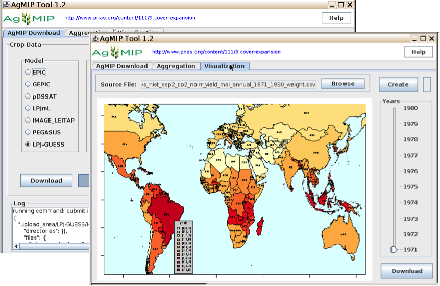
- AgMIP: a tool for aggregating global gridded crop model output
- Pegasus: a global crop model
- CMIP5 tool:This tool uses Sacks et al. 2010’s crop calendars for several crops to aggregate surface air temperature (average, minimum and maximum) and precipitation to user-defined world regions.
HydroShare
HydroShare is an online collaborative environment for the sharing of hydrologic data and models to help hydrologists in addressing critical issues related to water quantity, quality, accessibility, and management. It is funded by the NSF SI2 program and being developed by a CUAHSI team of participants from multiple institutions, including Purdue University.
 Purdue Terrestrial Observatory (PTO)
The PTO deploys a real-time multi-satellite tracking receiving station for polar orbiting satellites, including NASA's Terra and Aqua MODIS and NOAA's AVHRR sensors. The data are available for researchers for temporal and spatial analysis, data fusion and data mining of remotely sensed imagery.
IndianaView
IndianaView, a member of AmericaView, is a statewide consortium that promotes sharing and use of remotely sensed image data for education, research and outreach across universities, K-12 educators and government.
driNET
driNET is a research environment for collecting and disseminating local to regional scale drought information. driNET facilitates the publication of models, tools, datasets, training, and educational materials to help others with comprehensive evaluation of the causal factors of droughts.
TryCybSI
The IEEE-TryCybSI project came about from the IEEE Cybersecurity Initiative's efforts to provide an easily accessible, web-based platform for demonstrating common cybersecurity flaws and solutions. Docker containers and Amazon’s elastic compute cloud resources are leveraged to provide on-demand access to these applications while making the platform extensible and scalable on demand. The site’s usage data from the pilot phase revealed interest in the platform from around the world with users predominantly from the United States, China, South Africa, Spain and India. This project was a direct collaboration between the Scientific Solutions Group and faculty and students in Purdue's College of Computer and Information Technology.